LLP “U.U.Uspanov Kazakh research institute of soil science and agricultural chemistry” is a scientific organization of NASEC and today it is a leading institution in Kazakhstan engaged in fundamental and applied research of soil and agrochemical science.
Scientists of Kazakh research institute of soil science and agricultural chemistry is working on the study of the patterns of soil and soil cover formation and their assessment based on GIS technologies.
In the period 2009-2011 Institute’s scientists assessed the current state of agricultural land in southern Kazakhstan.
The current state of the soil cover of territories of intensive agricultural use of the South Kazakhstan region, including irrigated areas located on the left-bank and right-bank ancient alluvial plains of the river Syrdariya, as well as the territories of rainfed agriculture, confined to the foothill plains of the Western Tien-Shan. As a result of the studies, the main patterns of soil formation within the selected test plots (3 * 300 thousand ha) were identified, the features of soil transformation under anthropogenic impacts were studied. Based on the field studies and taking into account retrospective data, modern electronic soil maps of the selected test sites were compiled using geoinformation technologies and using satellite imagery, as well as maps of soil degradation.
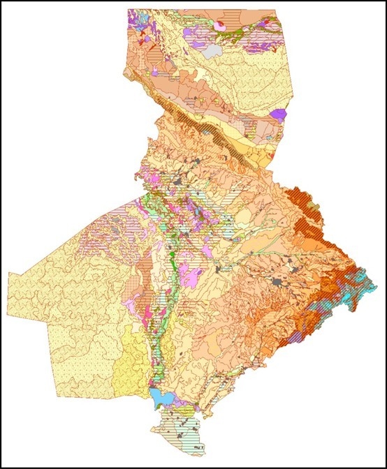
Also, in the period 2009-2011 the scientists of Institute studied the patterns of soil formation and mapping in southern Kazakhstan.
The morphogenetic properties of the soils of the territory were studied and the structure of the vertical zoning of the mountains and foothill plains of Southern Kazakhstan was specified. The structure was developed and a soil database is created. An electronic version of the soil map of Southern Kazakhstan on a scale of 1: 500000 has been compiled. Score scales for assessing the soils of the territory have been created and a map of the soil quality index of the south of Kazakhstan has been compiled. A scheme of natural zoning of the territory is developed and an electronic map is compiled.